Category Archives: geodesic

Astronauts in Space 'Feel the Power' of Hurricane Dorian as NASA's Florida Spaceport Braces for the Storm

By  Science & Astronomy 

space.com

Update for Sept. 3: As of 5 a.m. EDT, Hurricane Dorian has weakened to a Category 3 storm.

As Hurricane Dorian churned across the Bahamas Monday (Sept. 2), the storm's  awed astronauts in orbit with its raw power and set NASA's Kennedy Space Center in Florida on high alert for potential damage.

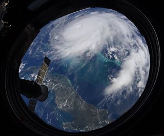
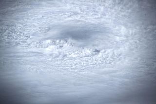
As of 11 p.m. EDT (0200 GMT), Dorian was stalled just north of Grand Bahama Island as the Category 4 storm battered the island with maximum sustained winds of nearly 130 mph (215 km/h), according to a National Hurricane Center update. Earlier Monday, the storm was hard to miss to astronauts looking down on Earth from the International Space Station.

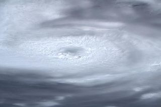
"You can feel the power of the storm when you stare into its eye from above," NASA astronaut Nick Hague wrote on Twitter while sharing a striking photo of the storm. "Stay safe everyone!"

Video: Here's the Latest Video of Hurricane Dorian from Space
Watch: 
See Hurricane Dorian in Action in these Gifs from Space

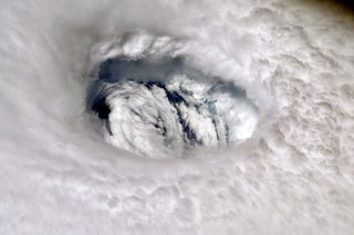
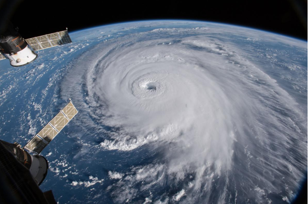
NASA astronaut Nick Hague of the Expedition 60 crew snapped this photo of the eye of Hurricane Dorian, a Category 4 storm, from the International Space Station on Sept. 2, 2019 as the storm stalled over the northern Bahamas.

(Image credit: Christina Koch/NASA via Twitter)

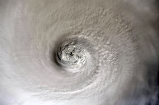
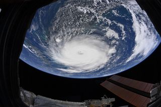
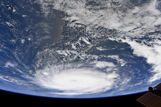
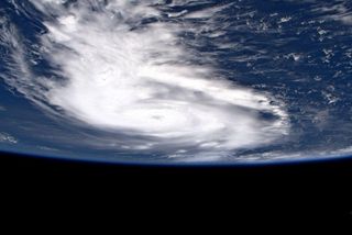
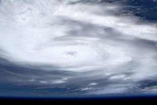
Hague's crewmate Christina Koch, also of NASA, snapped several more views of Dorian as the space station flew 260 miles (418 kilometers) overheard. Her four-photo series reveals the storm's eye up close, as well as views of the entire hurricane as it crossed the northwestern Bahamas.

"Hurricane Dorian as seen from Space Station earlier today," Koch wrote on Twitter. "Hoping everyone in its path stays safe."

Image 2 of 4

NASA astronaut Christina Koch of the Expedition 60 crew snapped this photo, one in a series, from the International Space Station on Sept. 2, 2019 as the storm battered the northern Bahamas.

NASA astronaut Christina Koch of the Expedition 60 crew snapped this photo, one in a series, from the International Space Station on Sept. 2, 2019 as the storm battered the northern Bahamas. The storm's eye is clearly visible in this close view.
(Image credit: Christina Koch/NASA via Twitter)

NASA astronaut Christina Koch of the Expedition 60 crew snapped this photo, one in a series, from the International Space Station on Sept. 2, 2019 as the storm battered the northern Bahamas.

The scale of Hurricane Dorian is evident in this view from the International Space Station by Christina Koch on Sept. 2, 2019. Portions of the Bahamas are also visible here.
(Image credit: Christina Koch/NASA via Twitter)

NASA astronaut Christina Koch of the Expedition 60 crew snapped this photo, one in a series, from the International Space Station on Sept. 2, 2019 as the storm battered the northern Bahamas.

An oblique view of Hurricane Dorian by NASA astronaut Christina Koch.
(Image credit: Christina Koch/NASA via Twitter)

NASA astronaut Christina Koch of the Expedition 60 crew snapped this photo, one in a series, from the International Space Station on Sept. 2, 2019 as the storm battered the northern Bahamas.

Hurricane Dorian stalled over the Bahamas as a Category 4 storm on Sept. 2, 2019. NASA astronaut Christina Koch captured this stunning view of the storm and some of the Bahama islands.
(Image credit: Christina Koch/NASA via Twitter)

At least five deaths have been attributed to Hurricane Dorian so far as the storm slammed the Bahamas with high winds and flood-inducing storm surges, according to the New York Times. Current models forecast Dorian will slowly turn northeast, approaching close to Florida's eastern shore and moving northward along Georgia and the Carolinas.

"On this track, the core of extremely dangerous Hurricane Dorian will continue to pound Grand Bahama Island into Tuesday morning," NHC officials wrote in their update. "The hurricane will then move dangerously close to the Florida east coast late Tuesday through Wednesday evening, very near the Georgia and South Carolina coasts Wednesday night and Thursday, and near or over the North Carolina coast late Thursday and Friday."

Related: How NASA and NOAA Track Hurricane Dorian from Space

NASA's Kennedy Space Center

@NASAKennedy

With Hurricane Dorian forecast to bring hurricane conditions to the Kennedy Space Center in just a few hours, 120 members of the “Ride Out Team” reported to the Launch Control Center to monitor and mitigate possible damage to spaceflight hardware @NASA

View image on Twitter
483 people are talking about this

Dorian's Florida approach has set NASA's Kennedy Space Center in Cape Canaveral there on high alert.

On Monday, the space center called in a skeleton crew of 120 workers, called a "Ride Out Team," to monitor the storm's effects on the spaceport and protect spaceflight hardware from damage. The team will oversee the space center during Hurricane Dorian from the historic Launch Control Center near the Pad 39 launch complex.

Photos from the space center showed KSC workers with camping backpacks, luggage, coolers and even an inflatable mattress, blankets and a space shuttle plush toy.

NASA's Kennedy Space Center

@NASAKennedy

Meet Madi: She’s riding out in our Launch Control Center, where our firing rooms are. Once its safe to go out, this industrial hygienist and her team immediately do a post storm hazard analysis at KSC. And if you can’t tell, she loves @NASA!

View image on Twitter
146 people are talking about this

A contingent from the U.S. Air Force's 45th Space Wing, based at the nearby Patrick Air Force Base and Cape Canaveral Air Force Station, is also at the Launch Control Center to help out. One Kennedy Space Center video shows military personnel making their way inside the Launch Control Center with their own supplies.

NASA's Kennedy Space Center

@NASAKennedy

With bearing down on the Space Coast, our friends from the ⁦@45thSpaceWing⁩ arrived to the ⁦@NASA⁩ Launch Control Center to shelter during the storm. Even the General is here!

Embedded video

273 people are talking about this

"With Hurricane Dorian bearing down on the Space Coast, our friends from the ⁦45th Space Wing⁩ arrived to the ⁦NASA⁩ Launch Control Center to shelter during the storm. Even the General is here!" KSC officials wrote on Twitter, referring to Brig. Gen. Douglas Schiess, who has commanded the 45th Space Wing for the last year.

The newspaper Florida Today is offering a live video stream of NASA's Kennedy Space Center courtesy of the paper's Space Team. The video stream, which is available directly from the Space Team's Facebook page, shows a view from the Space Team's building at the Kennedy Space Center, with views of SpaceX's facility at Launch Pad 39A and the United Launch Alliance's pad at Launch Complex 41 of the Cape Canaveral Air Force Station.

You can also see it embedded below, courtesy of Florida today.

If you live along Hurricane Dorian's path, visit the NHC and your local National Weather Service office for the latest forecasts. You can find the latest updates on Dorian from the NHC here.

Image 1 of 4

Astronaut Luca Parmitano of the European Space Agency captured this photo of the Category 5 Hurricane Dorian from the International Space Station as the storm moved across the Atlantic Ocean toward the Bahamas.

Astronaut Luca Parmitano of the European Space Agency captured this series of photos of the Category 5 Hurricane Dorian from the International Space Station on Sept. 1, 2019 as the storm moved across the Atlantic Ocean toward the Bahamas.
(Image credit: Luca Parmitano/ESA via Twitter)

Astronaut Luca Parmitano of the European Space Agency captured this photo of the Category 5 Hurricane Dorian from the International Space Station as the storm moved across the Atlantic Ocean toward the Bahamas.

This second photo from Parmitano shows a closer view of the storm. Its eye is clearly visible.
(Image credit: Luca Parmitano/ESA via Twitter)

Astronaut Luca Parmitano of the European Space Agency captured this photo of the Category 5 Hurricane Dorian from the International Space Station as the storm moved across the Atlantic Ocean toward the Bahamas.

This photo by Parmitano zooms in even closer on Hurricane Dorian's eye. At the the time this was taken, Dorian had just become the strongest hurricane on modern record.
(Image credit: Luca Parmitano/ESA via Twitter)

Astronaut Luca Parmitano of the European Space Agency captured this photo of the Category 5 Hurricane Dorian from the International Space Station as the storm moved across the Atlantic Ocean toward the Bahamas.

Hurricane Dorian's eye is seen up close in this zoomed-in photo by astronaut Luca Parmitano from the International Space Station, which orbits Earth from a height of about 260 miles (418 kilometers).
(Image credit: Luca Parmitano/ESA via Twitter)

Email Tariq Malik at tmalik@space.com or follow him @tariqjmalik. Follow us on Twitter @Spacedotcom and on Facebook.  

Have a news tip, correction or comment? Let us know at community@space.com.

This strange physical phenomenon explains why hurricanes and cyclones spin in different directions

Business Insider

Hurricane Andres (L) is seen weakening as Tropical Storm Blanca strengthens off the coast of Baja California, Mexico, as seen in this image from NOAA's GOES West satellite taken at 11:00 am EDT (15:00 GMT) June 2, 2015. REUTERS/NOAA/Handout
Hurricane Andres and tropical storm Blanca swirl off the coast of Baja California, Mexico.
 Thomson Reuters
We're smack in the middle of hurricane season, which means that many tropical vacation plans are about to be ruined by howling winds and bendy palm trees.

Hurricanes are called many different things — typhoons, cyclones, tropical cyclones — but they all have one thing in common: they spin.

If you've ever seen one of those swirly animations of a hurricane creeping from the ocean before it makes its frightening debut on land, you know what I'm talking about.

Fascinatingly, the direction of that spin depends on what hemisphere of the world the hurricane is brewing in.

A hurricane's spin and the spin's direction is determined by a super-powerful phenomenon called the "Coriolis effect." It causes the path of fluids — everything from particles in the air to currents in the ocean — to curve as they travel across and over Earth's surfaces.

The physics behind this natural phenomenon can be mind-numbingly complicated, but this YouTube video by Nova PBS does a great job of explaining things. Here's how it works:

During the 24 hours Earth takes to make one revolution around its axis, points along the equator (and therefore the air above them) move much faster than areas near the poles, because they have much farther to travel during the same amount of time.

You can see that in this gif below:

via GIPHY

That means that particles heading away from the equator are traveling at higher speeds than the ones closer to the poles. Because the globe is spinning, air and water therefore don't follow a straight path north or south.

Instead, anything traveling northward in the northern hemisphere gets pushed toward the right (from the perspective of its point of origin).

via GIPHY

Particles traveling from the equator to the south experience a similar curve in the opposite direction.

via GIPHY

Here's how that determines the spinning pattern of hurricanes: The area at the center of a hurricane has very low pressure, so the higher-pressure air that surrounds the eye of a storm naturally heads towards that middle area. But as the air rushes toward the center, it winds up moving in a curved path thanks to the Coriolis effect.

This creates a circular spinning pattern as air travels from areas of high pressure to low pressure.

That's why hurricanes originating in the northern hemisphere rotate counterclockwise.

via GIPHY

And those developing in the southern hemisphere spin in a clockwise direction.

via GIPHY

For further explanation on how the effect influences hurricanes, check out the full video here:

And FYI, this phenomenon doesn't explain the circular direction that water travels in your toilet bowl after you flush. A toilet bowl is too small to be affected by such a grand process.

Correction: A previous version of this story mischaracterized the pressure dynamics of air in hurricanes. The description has since been amended for accuracy.

 
Read the original article on Tech Insider.

Follow Tech Insider on Facebook and Twitter.

Copyright 2019.

CHECK OUT: Insane footage of South Carolina flooding caused by Hurricane Joaquin

NEXT: 15 of the deadliest, most destructive American hurricanes in history

Beyond nukes: how scientists dream of killing hurricanes

Cameras outside the International Space Station capture a sobering view of Hurricane Florence the morning of September 12, 2018, as it churned across the Atlantic. Scientists have dreamed and schemed for over 50 years about how to stop such storms in their tracks.


There are even stranger ideas for how to take down a tropical cyclone than bombing it with a nuclear warhead, as President Trump suggested.


A bizarre 60-year-old idea to fight hurricanes using nuclear weapons resurfaced this week after Axios reported that President Trump raised the possibility with his national security advisors. Trump later denied the report—but regardless, he wouldn’t have been the first to propose it or other wild schemes for stopping cyclones in their tracks.

Hurricane modification is on the scientific fringes today, but in the 1960s and 1970s it was a vibrant area of research, according to Phil Klotzbach, a tropical storm expert at Colorado State University. For several decades, the U.S. government even ran an experimental program aimed at weakening cyclonesby misting them with particles of silver iodide. Ultimately, the project was deemed to be fatally flawed and was abandoned.

Other ideas, like using cold water pumps to reduce a hurricane’s strength or soaking up its moisture with a Jell-O-like substance, seem even more far-fetched.

 
HURRICANES 101Hurricanes are the most powerful storms known to man. Find out when hurricane season peaks, how the storms form, and the surprising role they play in the larger global ecosystem.
 

Project STORMFURY

Possibly the most famous attempt to slay hurricanes was Project STORMFURY, a US government-led program that ran from 1962 to 1983.

In 1949, atmospheric scientist Bernard Vonnegut showed that silver iodide could be used to enhance the formation of ice crystals from supercooled water—water already below the freezing point—inside clouds. By spraying particles of silver iodide on hurricanes, government scientists thought they might be able to induce thunderstorms to form outside of the cyclone’s eyewall. This, they hypothesized, would prompt the eyewall to expand outwards, decreasing its top wind speeds.

Project STORMFURY conducted a range of experiments, including seeding four hurricanes on eight separate days. On half of those days, the hurricane’s winds appeared to weaken by up to 30 percent following silver iodide application. However, these results were later called into question when scientists learned that some hurricanes go through a natural process of “eyewall replacement,” in which outer rain bands form a ring of thunderstorms that migrates inward, weakening and eventually replacing the eyewall. Ultimately, researchers concluded it was this process that likely drove the hurricane weakening they saw in their experiments, not silver iodide.

“The experimental design [of STORMFURY] looked for Category 4 or 5 hurricanes with small eyes,” says Hugh Willoughby, a professor at Florida International University and former director of the National Oceanic and Atmospheric Administration’s (NOAA) Hurricane Research Division. “And those are exactly the hurricanes that are likely to do this.”

Soot and goo

During Project STORMFURY’s heyday, other scientists were thinking about different ways to attack cyclones from the air—like using tiny particles of black carbon, also known as charcoal, to diminish their winds.


Black carbon is a powerful heating agent that absorbs the sun’s energy and releases it into the atmosphere. Tropical storm meteorologist William Gray reasoned that if we used jet aircraft to spray plumes of it into the lower atmosphere, we could crank up the temperature over the ocean, enhancing the evaporation of water and promoting the thunderstorm formation. Similar to STORMFURY, Gray hypothesized that if those thunderstorms formed in the right place, they could weaken a cyclone’s eyewall.

Or, instead of accelerating cloud formation, perhaps we could squeeze hurricane clouds dry. In 2001, entrepreneur Peter Cordani made headlines for sprinkling Dyn-O-Gel—a highly absorbent powder that turns into a slimy goop on contact with water—into a cloud and reportedly making it disappear on radar. Cordani hoped the substance, which his company manufactured for diapers, could one day be used to dry up hurricanes.

But according to Willoughby, the Hurricane Research Division was never able to determine if the physics underpinning Cordani’s idea was actually solid. Even if it were, to have an impact on a hurricane you’d likely need tens of thousands of tons of Dyn-O-Gel. Ditto for black carbon, which may be why neither idea was ever tested on a cyclone.

Cooling the ocean

If we can’t fight hurricanes from the air, what about from the sea? Because cyclones get their energy from heat in the ocean, many scientists and inventors (including Bill Gates) have proposed cooling the ocean’s surface to sap their strength.

In 2011, a team of scientists crunched the numbers on what it would take to deploy an array of “wave-driven upwelling pumps”—pumps that use the vertical motion of waves to force cold, deep water up to the surface through a long tube—around Miami. They found that a system capable of reducing the ocean’s surface temperature by 1 to 1.5 degrees Celsius would cost between $0.9 to $1.5 billion annually. If we got the placement just right, the pumps could weaken a strong hurricane significantly before it made landfall, according to the researchers’ models.

“In principal, that would work,” says senior study author Kerry Emanuel, a professor of meteorology at MIT. The problem, in his view, is the economics of it. “You’d be better off sending people plywood to board up their houses,” he says.

A far more dubious idea that the Hurricane Research Division gets asked about regularly is towing icebergs from the planet’s poles into tropical waters. Beyond the fact that we’d likely need hundreds to thousands of icebergs to make an appreciable dent in ocean heat, there’s a more basic logistical issue with this scheme.

I think the most likely outcome is you’d have a radioactive hurricane.
KERRY EMANUEL, PROFESSOR OF METEOROLOGY, MIT

“The iceberg would melt long before it made it to the tropics,” Klotzbach said.

Fatal flaws

After more than 50 years of discussion and experimentation, it’s still unclear if we’ll ever be able to kill or even maim a hurricane. According to Klotzbach, all schemes suffer from two major hurdles: the unpredictability of hurricanes, and their sheer power.

“Hurricanes are just enormous,” Klotzbach says, adding that in a single day, a “typical” cyclone can release more energy than every nation on Earth combined. Put another way, the heat released by a hurricane is comparable to exploding a 10-megaton nuke every 20 minutes. Even if we devised a dissipation method that could match the power of such a storm, there would be the non-trivial task of knowing exactly where the hurricane will be, days in advance, in order to mobilize our defenses.

Finally, there are the potentially significant environmental consequences of fighting hurricanes. Altering the natural mixing of the ocean on a large scale could have enormous effects on marine life. Spraying millions of pounds of tiny soot particles into the atmosphere could create a serious public health hazard for anyone downwind.

Nuking a hurricane very likely wouldn’t do much to diminish it, Emanuel said. But from an environmental perspective, the result would be terrifying. “I think the most likely outcome is you’d have a radioactive hurricane,” he says.

Hurricane Dorian – live: Storm strengths to 'catastrophic' category five as it heads to Bahamas with 175mph sustained winds

independent.co.uk

Hurricane Dorian is moving towards the Bahamas and is expected to bring torrential rain and potentially dangerous conditions to the islands.

The storm may also hit the US and residents of coastal Florida and the Carolinas have been urged to monitor its progress.


A tropical storm warning has been issued on southern Florida’s east coast, while a tropical storm watch was also issued between Deerfield Beach down to Golden Beach.