What’s likely to happen when it strikes land?
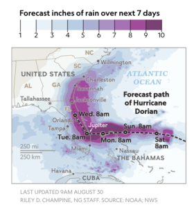
The National Hurricane Center is forecasting a slow-moving storm that could linger over Florida for 24 hours before moving on and dissipating.
High pressure over the mainland could force the storm to stall, says Haiyan Jiang, a tropical cyclone researcher at Florida International University. “We’re always watching that high pressure.”
When hurricanes finally make landfall and stall, the impact of floods generated by the storm’s rainfall can be massive. As we saw with Hurricane Harvey in Houston in 2017 and Hurricane Florence in the Carolinas in 2018, stalled storms can lead to massive flooding.

Forecast inches of rain over next 7 days
LAST UPDATED 9AM AUGUST 30
RILEY D. CHAMPINE, NG STAFF. SOURCE: NOAA; NWS
“If the storm slows down after landfall, that could dump a lot of rain. That will make things even worse,” says Jayantha Obeysekera, the director of the Sea Level Solutions Center at Florida International University.
He says recent rains have already saturated the amount of groundwater that can be absorbed in many parts of Florida. Storm surges will likely be worse because of a natural phenomenon called king tides, where tides are especially high when the moon is closest to Earth.
Dorian’s place in history
A large hurricane has not struck Florida’s Atlantic coast since Hurricane Andrew hit as a Category 5 storm in 1992. At the time, it was the costliest storm to ever strike the U.S.
Dorian is expected to hit as a Category 4 storm, meaning that the impacts may not be as catastrophic. But it will still cause damage.
In the 26 years since Hurricane Andrew, various parts of Florida have seen several inches of sea level rise. The rising waters likely won’t worsen what’s expected to be several feet of storm surge, says Obeysekera, but the hurricane’s impact could accelerate the coastal erosion.
So why hasn’t the east coast of Florida seen a major hurricane in 20 years?
Part of the reason may be due to a trend called Atlantic multidecadal oscillation, a natural cycle of warming and cooling thought to occur in the Atlantic Ocean on a roughly 20- to 40-year cycle. The oscillation could explain why Florida saw a spate of major hurricanes in the 1940s, Andrew in 1992, and now potentially Dorian.
“The other issue is that climate-change predictions are such that we could have stronger storms, and that’s also a factor,” says Obeysekera.
Experts caution against linking any one storm to climate change, but recentstudies show that warming waters could make hurricanes more intense, slower, and more likely to cause major flooding.
Taking precautions
By Sunday morning, Floridians could begin to see high winds and storm-like conditions. Though strong winds can cause major damage, sudden storm surge and flooding contribute most to injury and death.
